Mount Madison, Adams Hike
This is a relatively brief description of a hike to Mount Madison, Adams in the White Mountains in New Hampshire, USA.
Date: 2008-03-17
Total distance: 9.9 miles (15.8 km)
Total Time: 8 hours
Start elevation: 1300 ft (397 m)
Peaks: Mount Madison (5366 ft, 1637 m), Mount Adams (5799 ft, 1769 m)
The following is a picture from Google Earth that does not reflect
the weather condition of the hike. More pictures are at Picasa.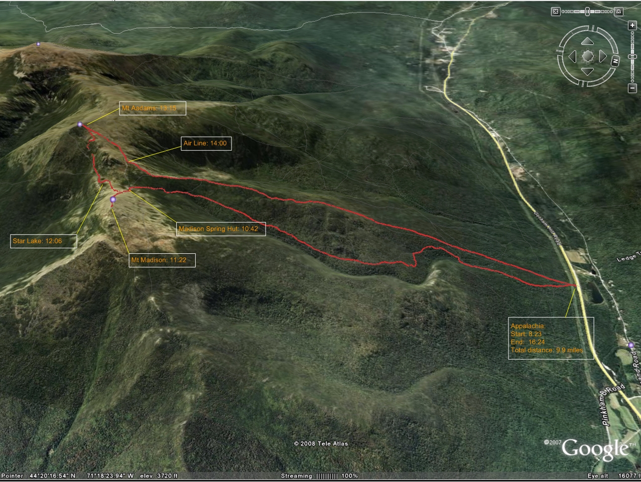
Prologue
After a very pleasant hike to Mount Lafayette on February 23, 2008, my interest in winter hike and x-country skiing in the White Mountains increased significantly. Among the 8 peaks higher than 5000 feet in New England, I had hiked 4 so far (Washington, Monroe, Lafayette and Lincoln). I planned to visit the other three adjacent 5000 footers in the White Mountains (Adams, Jefferson and Madison) as soon as the opportunity came. The one in Maine (Baster Peak) would be handled in the summer. I kept watching weather to find dates when I do not have to go against the higher power by fighting heavy snow or strong wind. Toward to the weekend of March 1, I was certain that Sunday March 2 would be an acceptable day for hiking. I decided to hike to Jefferson first and then march toward Adams and Madison to see how far I would be able to go before a safe return. I booked a room at AMC's Joe Dodge Lodge at Pinkham Notch for Sunday March 2. When I was planning the driving on the Saturday afternoon, I realized it would take 3.5 hours to drive to the starting point - Appalachia. If I left home at 5:00, I would be there at 8:30 losing about 2 hours of precious daylight time. If my arrival was delayed for any reason, I would lose even more. To increase the chance to visit all three peaks, I decided to do the hike on Monday March 3 after staying at Joe Dodge overnight. I could not find weather forecast for the peaks, so I had to use the weather forecast for close towns to extrapolate for the mountain.
I did 5.8 miles of x-country skiing on Saturday March 1 at Appleton Farms in very wet snow. It was not nearly as pleasant as skiing in those extremely well maintained trails of the Great Glen Trails near Joe Dodge. It made me look forward even more to skiing at Great Glen Trails.
On Sunday, March 2, I arrived at the Great Glen Trails at 11:30 after getting a ski pass voucher at Joe Doge. I tried to signed up for a group lesson for intermediate skier, but the instructor had been fully booked. After a quick lunch of pizza, potato salad and orange juice, I hit the trails. Because of strong wind, the trail condition was not as good as last time especially in open field where there are many drifts. I skied for about 3 hours involving many falls. I ventured into quite a few trails marked as "more difficult". I was humbled by kids of about 6 or 7 years old skiing elegantly on the trails where I fell.
To find out the trail condition after returning to Joe Dodge, I talked to Katie at Joe Dodge's visitor center. She kindly searched online and called a person from Randolph Mountain Club which maintains most trails on the north side of the Presidential Range. It seemed that the primary trails were well broken, but the trails I was thinking about to use for ascent were not. At dinner, I sat with Brian from Atlanta, Patrick from DC and another guy from California. They tried to summit Mount Washington and one of them succeeded in spite of strong wind. A group from Montreal were also at our table. I could not understand a word of French they were speaking.
After dinner, I had a conversation with Kellie at Joe Dodge's front desk who apparently is a very experienced hiker. She happened to break the Randolph Path in the morning. That is the path I planned to take for ascent. After a good night of sleep, I enjoyed a hearty breakfast while chatting with Tom from Boston. He brought up an interesting observation regarding the different levels of interest in hiking or mountaineering among different ethnic groups. I checked the weather with Lynne at the Visitor Center and found the wind on the ridge would pick up to 80 mph. In this case, I changed my plan to summiting Madison and Adams without walking miles on the ridge toward Jefferson. The original plan of reaching Jefferson first and then heading toward Adams and Madison on the ridge would be very risky under strong wind. I decided to take Air Line to Adams, then summit Madison and take the well sheltered Valley Way back when the wind would be very strong in the after noon.
Failed first try
When I arrived at Appalachia at about 8:10, I was the only person there. I thought this might be because it was a weekday. I started my hike at 8:18. It was calm. As usual, I was wearing a double layer water proof running pants, a Drylete long sleeve and a Boston Marathon jacket. Very soon I had to take my gloves off because constant ascending made me quite warm. The trail was well broken but not quite packed down. I had to put on my snow shoes within a mile. At 1.4 mile I was so warm that I had to take off my jacket and wrapped it around my waist. Soon I started to hear wind and felt the temperature drop. I put on my jacket at 2 mile. I ascended above the tree line at mile 2.4. The wind was howling. It blew almost perpendicularly to the knife-edged ridge. I used a rock as a partial shelter from the west wind and replaced my snow shoes with crampons. I started having difficulty standing straight. I had to bend frequently to avoid being blown away. Very soon, I realized summiting was out of the question. I took a look at the map and decided to ascend to the Air Line Cutoff and get to the well sheltered Valley Way as soon as possible.
I passed upper Bruin coming up from the left and then Chemin des Dames from right. Air Line Cutoff should be only 0.3 miles away. The wind was getting stronger and sky was getting darker. Suddenly wind gust mixed with pouring freezing rain. I was soaked in seconds and I could not see any sign of Air Line Cutoff. From the distance that I have traveled from Chemin des Dames, I knew I must have been extremely close to the cutoff. It was very difficult to continue going up and the worst thing was that I was not sure that I would be able to find the cutoff. I was having hard time stabilizing myself and could barely see my own footprints in the snow. I decided to return on the same trail to get any uncertainty out of the way. In rain and wind gusts, I descended frantically. The knife-edge is dangerous, but it offers no chance to get lost. I ran down as fast as I could to reach below the tree line. Once below the tree line, it was like in a different world. I took off crampons to save energy because when descending, slipping is not a problem as long as one does not fall. Actually sometimes gliding is even preferable. The rain stopped soon. Probably I happened to be hit by the worst gust and rain on the knife-edge. If I had reached there half an hour earlier or later, I might have been able to reach at least the Air Line Cutoff to take the Valley Way for return.
I returned to Appalachia, my car was still he only one in the parking lot. I looked for a Chinese restaurant to get some hot and sour soup, but both of the Chinese Restaurants in Gorham were closed. I picked my laptop and bag from Joe Dodge and talked to Kellie and Lynne briefly about this failed hike. I stopped by China Chef in North Conway to order twice-cooked pork and hot and sour soup. I found this restaurant is much better than the other one I tried twice before.
Second try
I kept watching the weather forecast of the White Mountain region and decided the weather would allow me to give another shot on Monday March 17. I left home at 11:10 on Sunday and stopped by China Chef to get a Human Pork lunch while enjoying the fantastic view in my car parked at the Scenic Vista. I stopped by Joe Dodge to book a bed and dropped my suitcase there, then headed for the Great Glen Trails. It was almost 15:00 when I started my skiing. I spent the first hour on the hilly trails and focused on drilling my plowing technique. I spent the next 70 minutes practicing diagonal and skating on the trails of the large flat fields. I noticed that I was the only person on the trails. When I got back to the store of the Great Glen Trails, it was closed and my car was the only one in the parking lot. Later I found that the store closes at 16:30 daily.
After a hot shower at Joe Dodge, I checked the weather forecast and was discouraged. The wind on the summits would be up to 80 MPH. Summiting seemed to be in jeopardy. Katie at the information center helped me again to find the trail conditions. Contrast to the impression I got from weather forecast, there had been very little snow in the past few days so the popular trails were well packed down, so I would not even need to bring snow shoes. It was a relief. It is not the weight of the snow shoes but the hassle of securing them to my backpack and putting them on and taking them off in cold and windy conditions that bothers me.
At dinner, I sat with Frank from New Jersey, Paul from Weymouth of Massachusetts and Miguel from Montreal. Our conversations, as usual, covered hiking, but somehow extended to Basques Country of Spain, Kosovo independence, etc. I spent two hours in the reading room writing with my laptop
After a good night of sleep in a room with 4 beds but only one person, I ate a hearty breakfast of cream of wheat, potatoes, sausage, eggs, pancake, orange juice and tea. Frank was also going to the north side of the Presidential Range and stay in the huts for a few days. I told him that I might take Randolph path when coming down after reaching the peaks and have a chance to see him there.
When I reached Appalachia, there were already two cars there. I was glad that I was not the only person hiking in that area like last time. My hike officially started at 8:23. The Valley Way was well packed down, so I started climbing without wearing crampons. The Valley Way is well sheltered and has moderate inclination all the way to the Madison Spring Hut. I found very soon that the footprints showed one person was not very far before me. The footprints were getting fresher and fresher meaning I was getting close to the person. I was wearing a pair of Spyder Gore-Tex pants that have side zippers. I had the zippers open to keep my legs cool. I was wearing only the inner fleece layer of my Columbia jacket. Its outer Omni-Shield layer was in my backpack. I forgo to bring a hat or headband with me, so I had to fold up my balaclava to wear it as a hat to keep my ears warm when approaching the tree line. Once I was above the tree line, I could feel the strong wind, but the view was fantastic.
The Madison Spring Hut is a probably 100 meters away from the tree line. I thought someone told me the hut was open so I planned to get into the hut to put on proper clothes and look at the map before starting attacking the peaks. I finally saw the person before me at the Hut. His name is Scott Loeber from Littleton, New Hampshire. The time was about 10:40. I learnt the hut was closed. Scott was also going to Madison and Adams, so we decided to go together. I used a wall of the hut to partially shelter from the strong wind and put on the outer Omni-Shield outer layer of my jacket and wore my balaclava with full cover, closed the zippers of my pants. When I was just about to start, Scott noticed that I was not wearing my crampons. Since the wind could get people cold quickly, I asked Scott to go ahead without waiting for me and I spent almost 10 minutes to take the crampon off from my backpack and secured them to my boots. I followed the Osgood Trail to the Madison summit. The trail gradually shifts to the south side of Madison so I felt less and less of the north wind. I met Scott who was coming down at about 100 meter from the summit. He was taking a break to eat some food and drink some water. I continued to the summit and reached it at 11:22. Though the wind hurt, but the views were spectacular. The visibility was infinite. I took quite a few pictures. I came down and met Scott again. He noticed two hikers were climbing the steep slope of Adams in distance. I used binoculars and watched them. Scott suggested follow them to the Adams. Looking at the steep slope they were dealing with, I was not sure.
We started descending together. Scott is a very experienced hiker. He moved from Albany, New York to New Hampshire because of his love for the White Mountains. Apparently he felt very comfortable and confident with his walking on crampons. He moved like a goat. It was only my second time wearing crampons. Though I had never slipped with crampons, but I was very cautious with my steps on the solid ice that covers most of the ground of the exposed surface. We were heading toward the Madison Hut. I suggested take a short cut toward the two hikers and so we did. In minutes, we reached the Star Lake which water was apparently solid ice. The time was 12;06. The "lakes" on the mountain are usually small ponds.
We followed a trail on the south side of the lake, which I later found is Buttress Trail and we saw some signs on the north side, so we went there. We found the Star Lake Trail leading to the summit of Adams. We found the footprints of the two hikers and started following them. Scott found an ice axe. We were on the southeast side of Adams largely sheltered from the strong northwest wind. The surface was largely solid ice with patches of snow, or deep snow in a few areas. The inclination is somewhere between 40 and 60 degrees. I noticed the two hikers took a path straight up to the ridge and we decided to take a diagonal path straight toward the summit of Adams. The next 50 minutes were the most nervous time I had ever had in hiking. According to Scott's advice, I had to kick every step to make sure I had solid grip on the ice on steep slopes. Scott slipped once but he saved it. I almost slipped once. I was constantly searching for paths offering more friction by rocks, shrub branches. There are segments that were just solid ice on steep slope. If one falls, I figure, he can gain 0.5g. Within 50 meters, his gliding speed will be 80 kph, or 50 mph. Not only was I concerned about my safety, but also about Scott's. If he fell down to the deep ravine , I would not be able to provide any help except to call 911. I thought it was simply too dangerous to continue the diagonal path and it would not save us any time considering how slowly I was moving due to extreme caution. I suggested take a relatively safe path to the ridge first and so we did. We met the two hikers coming down from the summit of Adams soon after we got on the ridge. They are apparently the owners of the third car at the Appalachia. They told us, in Russian accent, that they camped near the Madison Hut last night. They told Scott they did not lose the ice axe that Scott found.
We reached the summit of Adams at 13:15. My camera ran out battery at the most dangerous section and the backup alkaline batteries are simply not good at low temperature for my Kodak Z650, which is supposed to use rechargeable batteries, . Scott used his traditional SLR to take a picture of me at the summit. Scott refueled again and we started descending to the junction of Air Line Trail and Gulfside Trail. I had three pairs of gloves with me with different thickness and I was wearing the intermediate one. We were against the strong wind. The wind chill caused bitter pain on my fingers. I chose to ignore it and tried to descend as fast as we could thinking the wind chill would decrease with the descent and my circulation and blood temperature would increase with my moving fast. It would be very hard to stop in strong wind gust to find the thickest cold gloves in my backpack and substitute them. When we reached the Gulfside Trail, I could feel the wind chill was significant weaker than the summit.
Soon after I stepped on the knife edge of the Air Line off the Gulfside Trail at 14:00, I realized I could use my at&t 8525 mobile phone to take pictures. I took it out and started taking pictures but soon I found its battery was low. In a few minutes, the wind dropped significantly. I do not know how much it had to do with the altitude and how much with the actual subsiding of the wind. With weaker wind, good footing, I lost caution and fell awkwardly at a spot very close to the brink of King Ravine. The handle with a compass of a hiking pole was broken. It took me a while to stand up. Scott had another session of refueling and I also took the opportunity to drink some water for the first time at the junction of Chemin Des Dames and Air Line. The view of King Ravine form the knife edge was spectacular. I confirmed that I was not very far from the Air Line Cutoff to the Madison Spring Hut last time before I was driven back by wind gust and freezing rain. As I suspected, the sign of Air Line Cutoff was gone leaving only a wood pole.
Once I was below the tree line, I decided to take the time to take off my crampons as I did last time and asked Scott not to wait for me. To my surprise, the trail was much slippery than last time and I had to glissade in sitting positron many times over steep sections. It was a sort of fun. In the middle of Air Line trail, I saw big. deep round animal footprints. They were like footprints of elephants that I have see in films. I could not figure out what animal left the footprints. I did not see any broken trails branching from the Air Line until very close to the Appalachia. I arrived at Appalachia at 16:24. Scott, who moves like a goat on crampon when descending, was waiting for me there and gave me his business card. He is a licensed massage therapist. He told me he followed a moose and her calf for a short while and it explained those large animal footprints that I saw. We chatted briefly before he headed home.
Epilogue
I went to Joe Dodge to fetch my laptop and a small bag with valuables. Unfortunately they did not have a microwave to heat the mushroom soup that I brought with me and was craving for. I stopped by the Visitor Information Center to thank Katie for all the helpful information she provided. Their computer could not read my camera's SD card, so I uploaded the photos the next day for them to download. Katie said the pictures were helpful for explaining the trail conditions.
I stopped by China Chef again to get Singapore Style Rice Noodle and was back home at 20:30.
It was clear the next day that three finger tips of my right hand had frostbites. I have no doubt there were produced by the bitter wind chill during the 20 minutes or so descent from the summit of Adams. My right ankle was also slightly injured. and I had a little bit difficulty walking fast when catching T's to go to the Microsoft's Launch event in Boston the next day. However, within a week I could run 5 or 6 miles without any problem.
I could not wait to go back to hike the three peaks as I originally planned: Madison, Adams and Jefferson.
Weather statistics of the day for Mount Washington (the weather for other peaks of the range should be similar and slightly milder)
Tuesday, March 18, 2008
4:43 AM
24 Hour Statistics
Maximum Temperature: 11°F
Minimum Temperature: -3°F
Peak Wind Gust: NW 80 mph
Average Wind Speed: 45.4 mph
Liquid Precipitation: 0.15"
Snowfall: 1.3"
